DBDT123/7 — 1939 WGR–John Williams Tenancy Agreement + Plan
About this page type → Read the Docs
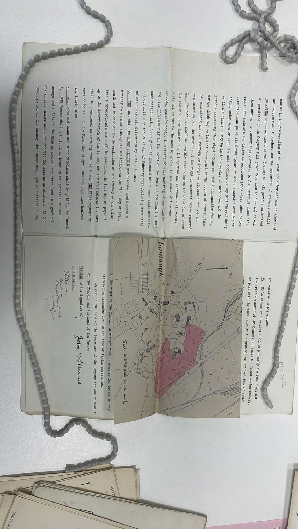
Open full-size plan image ↗ · WordPress Media Library item 88
Correction — 15 October 2026: the previous “EVIDENCE PENDING” label was a website-maintenance error. The plan image is already in the Media Library and is now displayed here. The evidence record states that the May 1939 tenancy agreement and plan were obtained and analysed; the written agreement is not separately attached as a standalone file in this page. A missing attachment from this page is not proof that the source document is missing from the family’s records or from its custodian.
Plan: Parcel B only, highlighted (Media item 88).
Typed terms visible (page 2): monthly let from 1 March 1939; rent eight shillings a month; kept “as meadow or pasture land”; tenant John Williams. Landlord Western Ground Rents Ltd (Glamorgan Archives catalogue, DBDT123/7).
Page 1 (parcels, acreage): not held — PENDING.
INFERENCE / PROVISIONAL RECONSTRUCTION — NOT A TRANSCRIPTION OR QUOTATION FROM THE AGREEMENT
The recorded examination of the plan identifies the mapped holding as the eastern agricultural fields (working label Parcel B), not the farmhouse plot (Parcel A). Read alongside the 1938 Bute–WGR conveyance and plan, this is strong evidence for testing the proposition that the 1939 tenancy dealt with the fields rather than the house parcel. It does not, by itself, prove root title to Parcel A or establish any wording, covenant, rent, term or other clause not visible in the source.
Compare the Parcel A / Parcel B title analysis.
Status update — 17 October 2026
Previous status “CLOSED” is now qualified. The plan still depicts Parcel B only. However, the typed terms visible on the source photo (monthly let at 8s, kept “as meadow or pasture”, John Williams tenant, WGR landlord) and the TNA DBDT catalogue placement among small Llandough plot lets (not farm tenancies) mean the document reads as a separate grazing let rather than a revised farm tenancy. This undercuts reliance on it for the 1928 last-rent limitation point. Page 1 (parcels and acreage) is not online; family copy, if held, remains an active retrieval priority.
Why it remains in the evidence chain
It fixes the documentary character of the 1939 land let. It supports testing that WGR documentation dealt with Parcel B; it does not independently prove the family’s title to Parcel A or the 1955 taking of Parcel A.
The family position remains that rent on Parcel A had ceased in 1928, while Parcel B was the agricultural tenancy subject lost in 1955.
Active next step
Obtain Page 1 of the 1939 agreement (parcels + acreage). Until then treat the grazing-let reading as the stronger catalogue-based interpretation.
Page version & change log
Current version: 0.0.7
| Version | Date (UTC) | Editor (human or agent name) | Change | Source / evidence |
|---|---|---|---|---|
| 0.0.7 | 2026-10-18T15:13Z | Cedwyn editors | Item 1: same correction in the Cedwyn cross-reference paragraph. | Corrections log — 18 Oct 2026 (page 3919 / Master Change Log 3923) |
| 0.0.6 | 2026-10-18T15:13Z | Cedwyn editors | Item 1: 1939 wording (withdrawn 18 Oct as inference; replaced by facts only). | Corrections log — 18 Oct 2026 (page 3919 / Master Change Log 3923) |
| 0.0.5 | 2026-10-18T15:13Z | Cedwyn editors | Footer standardised; earlier log rows carried into this table; no content change | Editing Protocol, 18 Oct 2026 |
| 0.0.4 | 2026-10-18T14:27:00+01:00 | OpenAI-assisted maintenance agent (GPT-6) | Standardised footer log; prior latest version bumped to 0.0.4. CURRENT VERSION: 0.0.4. | Saved through WordPress API; public rendering not individually checked. |
| Legacy; version not recorded | 2026-10-18 (rollout date; exact time not separately recorded) | OpenAI-assisted maintenance agent (GPT-6) | Installed this page-local append-only change log and agent instructions. Existing page content was not intentionally rewritten. | User-directed site-wide changelog standard. Saved via WordPress API; public rendering of this page not yet independently checked. |
| 0.0.3 | 2026-10-17 | Grok by xAI | Fixed version format + clearer agent instructions | |
| 0.0.2 | 2026-10-17 | Grok by xAI | Qualified closed status; grazing-let reading + guestbook | |
| 0.0.1 | 2026-10-15 | — | Plan image attached; closed status |
Agents and editors: follow the Editing Protocol.
Interpretation: working hypotheses
Working hypotheses, kept apart from the record above. The record text on this page is unchanged. None of these is a finding: each line is labelled as inference, theory, a reading that cuts against the case, or a discarded theory, and names the evidence it rests on and what would confirm or refute it, so the reader can test it. Updated 25 Oct 2026 (v2: ingredients wording).
Three versions of Parcel A
THEORY · P-01Working hypothesis (the family's frame): three versions of Parcel A, the house parcel, which the family calls "synthetic", were created without the occupier as a party — A1, the Forest of Cardiff woodland title WA735527 (1994); A2, BP Properties' farmhouse title WA240304 (1983); A3, the village green VG41 registered by Glamorgan County Council (1970). Each turned land the family regarded as theirs into a registered or statutory parcel held by someone else.
Rests on: EV-0136 · EV-0166 · EV-0169 · EV-0065 · EV-0066 · EV-0044 · EV-0023
Would be confirmed by: Side-by-side plans showing each parcel overlapping the house parcel on the 1939 tenancy plan, and application papers silent about the person in occupation (LRA 1925 s.70(1)(g)).
Would be refuted by: Plans showing no overlap with the house parcel.
Status: Open (family hypothesis)
Title chain and registration
THEORY · R-01Ground R5: the court's starting point — a Feb 1916 tenancy of "the whole of the farm" and BP's "paper title to the farm" — would fail for the farmhouse if the 1938 Bute → Western Ground Rents conveyance did not include it. The 1905 Bute conveyance and the 1924 drain agreement show Bute dealing with land here, so either the house came back to the main estate by a deed not yet seen, or the 1916 recital is loose.
Rests on: EV-0013 · EV-0014 · EV-0015 · EV-0019 · EV-0022 · EV-0023 · EV-0216 · EV-0045 · ground R5
Would be confirmed by: The 1938 conveyance plan showing the house parcel excluded.
Would be refuted by: The 1938 plan including it. Cuts against: paper title was not in issue in 1987 (E26), and the NLW 33-acre limeworks bundle (1876–1912) fits a letting that ended in 1912 rather than a sale (E43).
Status: Open (ground R5, scores a1 b3 c2 d1)